Our team of editors and experts thoughtfully chooses each product. If you decide to buy through one of our links, we may earn a commission. Learn more. Want to know how we test products? Click here for more details.
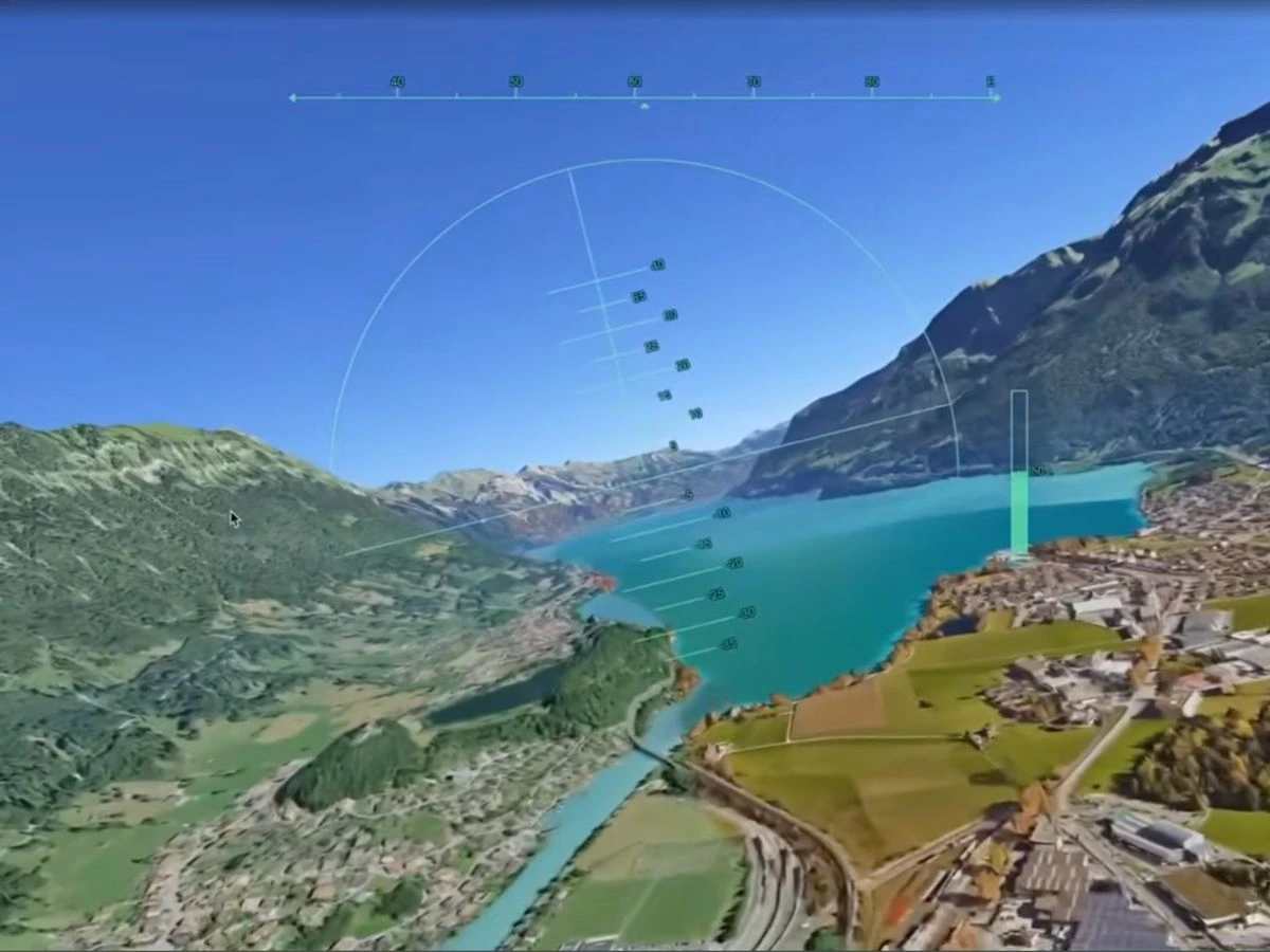
Google Earth’s experimental Flight Simulator is now available globally through the web, with no desktop application required.
Users can fly over almost anywhere on the planet using keyboard or mouse controls, with simplified physics designed for casual exploration.
Switching from Map to Satellite view adds high-resolution imagery, terrain and dynamically loaded 3D buildings.
Faster flying or a low-bandwidth connection may cause loading delays, while some low-altitude areas can experience visual clipping.
Crashing pauses the simulator and provides an instant restart, returning the aircraft to a safe altitude without any paperwork from air traffic control.
If you have ever opened Google Earth, found your house and then immediately started exploring places you have never visited, there is now another way to lose an afternoon. Google has brought its experimental flight simulator to the Google Earth Browser Version, allowing anyone with a computer and a web connection to fly around the planet without downloading the desktop app.
For readers who love planes, airlines or simply seeing familiar cities from a completely different angle, the feature offers a wonderfully low-commitment way to take to the virtual skies. You can skim above city skylines, follow coastlines or attempt to thread your aircraft through mountain valleys using Google Earth’s streaming 3D buildings and satellite imagery.
Just do not expect Microsoft Flight Simulator-level realism.
Google describes the experience as a casual exploration tool with simplified flight physics, so there are no detailed cockpits, airline schedules or hours of training required before take-off. All you need is a browser, a keyboard or mouse and a location worth flying over—although keeping the plane in the air may still take a little practice.
How to Use Google Earth’s Flight Simulator in Your Browser
Getting started is surprisingly easy. Open Google Earth on your computer and select Explore Earth from the home screen. Once the globe loads, choose the place you want to explore using the search bar, whether that is New York, the Canadian Rockies, the California coast or somewhere much closer to home. Google says the feature is now available globally on the web, giving users around the world access without paying for separate flight-simulation software.
Next, open the Tools menu along the top of the page and select Flight Simulator. Google Earth will move from its regular map interface into a simple flying experience that runs directly inside your browser, so there is no desktop application to download and no separate game installation standing between you and take-off.
Before flying, switch the basemap from Map to Satellite. Google Earth uses the abstract map by default, but Satellite view brings in the photorealistic imagery, terrain and 3D buildings that make flying over real places much more interesting. From there, your virtual travel list can include Sydney Harbour, the Grand Canyon, Tokyo, the Alps, your childhood neighbourhood or almost anywhere else you can locate on the globe.
Now comes the slightly trickier part — keeping the plane in the sky.
Use Page Up to increase thrust and Page Down to reduce it, while the arrow keys control pitch and banking. The up arrow makes the aircraft climb, the down arrow points it towards the ground, and the left and right arrows bank in their respective directions. You can also click inside the simulator to toggle mouse-based controls, although whether that improves your relationship with gravity is another matter entirely.
If you crash, the simulator pauses and gives you a Restart option, returning the aircraft to a safe altitude without making you repeat the entire setup. When you have finished flying, select the back arrow in the upper-left corner to return to the regular Google Earth map. Microsoft Flight Simulator already has detailed aircraft systems and precision aviation covered; Google’s free alternative is something you open for fun when you want to fly over places you know—or places you may never get to see in person.
What to Expect From Google Earth’s Browser Flight Simulator
Google is fairly upfront about what this flight simulator is—and what it is not. The feature uses simplified flight physics and is designed for casual exploration rather than high-fidelity aerodynamic training, so nobody is walking away from a ten-minute flyover of Manhattan ready to command an Airbus A350.
You will not find detailed airline procedures, interactive cockpit systems, an FMS to program or an ILS approach waiting at the end of a long-haul sector. Google Earth gives you a plane, a planet-sized map and just enough control to make you appreciate how much work goes into keeping a real bird straight and level.
Think of it as Google Earth with wings.
The scenery is the real attraction. As you fly, Google Earth dynamically streams 3D buildings and high-resolution imagery into the browser, meaning every trip changes depending on where you point the nose. City skylines, mountain ranges and coastlines make for the best virtual sectors, particularly after switching from the basic Map view to Satellite.
Your internet connection also becomes an unofficial member of the flight crew. Google warns that travelling at extreme speeds or flying with limited bandwidth can cause temporary loading delays as the platform attempts to render the world beneath you. You may achieve positive rate, but the city below could still be waiting for clearance to appear.
The feature remains labelled Experimental / pre-GA, so a few technical quirks are already on Google’s squawk list. Low-level flying in areas below sea level, including Badwater Basin in California, may produce flashing or terrain clipping, while standard Google Earth map shortcuts are disabled during a flight to prevent them from interfering with the aircraft controls.
The good news is that an unscheduled arrival into the terrain is not the end of your aviation career. When the aircraft hits the ground, the simulator pauses and displays a “You crashed! Restart” button, placing you back at a safe altitude and location. No Mayday call, accident report or awkward conversation with the chief pilot required.
Google Earth’s Flight Simulator is available globally through Google Earth on the web. Choose somewhere scenic, activate Satellite view and remember the first rule of casual browser aviation: keep the blue side up and the brown side down.
Elias Albay is the Founder and Director of Many Men Magazine, a Toronto-based digital publication dedicated to promoting modern masculinity through style, culture, and self-improvement. What started as a personal turning point became a purposeful platform. — born from Elias’ desire to create something meaningful after completing his studies and finding no career path that truly matched his ambitions. With a background in Civil Engineering from York University and experience in Commercial Flight Operations at CAE, he applied skills, and resilience from both fields to forge a new path.
Our team of editors and experts carefully selects each product. If you choose to purchase through one of our links, we may earn a commission. Learn more. Do you want to know how we test products? Click here for more details.
Cutting back on alcohol doesn’t mean you must cut back on taste. The world of non-alcoholic gin has exploded, and today’s options are nothing like the watery imitations of the past. Crisp, botanical, and full of flavour, these bottles bring all the character you love about a good gin — minus the buzz and the next-day regret. Whether taking a break, pacing yourself, or wanting to shake up your bar cart with something different, these non-alcoholic gins deliver the real-deal experience. From bold, juniper-forward blends to refreshing citrus and herbaceous hits, we’ve rounded up the best bottles that prove going alcohol-free doesn’t mean going flavour-free. Ready to pour yourself something great? Let’s get into it.
Flavour: Classic juniper, natural botanicals, hint of citrus
Best For: Traditional gin lovers going zero-proof
Price: USD $40
If you’re looking for a non-alcoholic gin that remains authentic to the classic London Dry style, Monday Non-Alcoholic Gin should be your first choice. It’s crisp, aromatic, and delivers that bold juniper punch from the very first sip — no strange aftertaste, no watery letdown. Consider it the spirit that allows you to enjoy a proper G&T without feeling like you’re missing out on anything. Monday Gin uses natural ingredients and is distilled for authentic gin flavour. It features a backbone of juniper and fresh botanicals with a hint of citrus. Being sugar-free, gluten-free, calorie-free, and vegan suits various lifestyles. Whether mixing a tonic or martini or enjoying it over ice, Monday enhances your experience.
Ritual Zero Proof Gin Alternative | Image: Ritual Zero Proof
2. Ritual Zero Proof Gin Alternative
Brand: Ritual Zero Proof
Spirit Type: Non-Alcoholic Gin Alternative
Flavour: Bright botanicals, juniper, cucumber, mint
Best For: Cocktail lovers who want a bold, refreshing base
Price: From USD $32.95
Ritual Zero Proof Gin Alternative is a go-to if you’re chasing that refreshing, botanical snap without the alcohol. It leans into a bright mix of juniper, cucumber, and mint, giving it a crisp, cooling vibe that feels right at home in a classic gin and tonic. With just the right amount of bite, Ritual’s gin alternative is perfect for building out cocktails that taste absolute — not watered down. It’s crafted to be low-calorie, gluten-free, and vegan, making it a bright, easy swap for anyone who wants to mix like a pro without the buzz.
Best For: Summer spritzers and bright, refreshing cocktails
Price: USD $35
Optimist Botanicals Fresh is a perfect pick if you’re looking for something light, crisp, and a little playful. With bright citrus, fresh herbs, and a floral, it’s crafted to taste like California in a bottle — clean, sunny, and effortlessly cool. Designed more for bright spritzers than heavy cocktails, Fresh is ideal when you want something refreshing that feels slightly different but still hits all the right notes without the alcohol.
Best For: Fresh, outdoorsy cocktails or simple highballs
Price: USD $39
Inspired by the Cornish coastline, Pentire Adrift brings a fresh, herbal vibe infused with coastal botanicals, bright citrus, and a hint of sea salt to finish. It’s clean, crisp, and evokes the sensation of ocean air in a glass. If you seek a non-alcoholic spirit that feels more outdoorsy and earthy than classic gin, Adrift is an excellent choice for mixing simple highballs or sipping over ice.
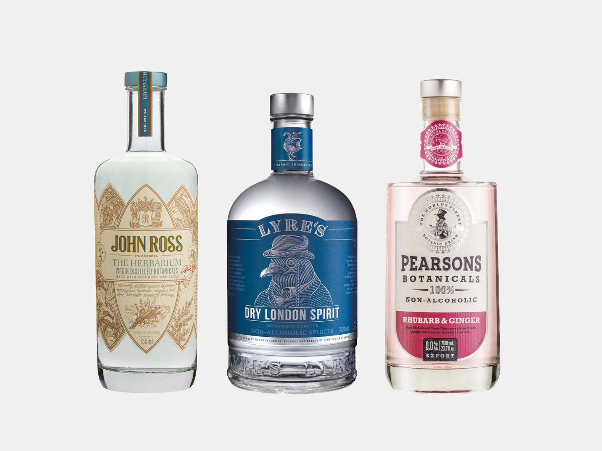
Lyre’s Dry London Spirit captures the essence of traditional gin, offering bold notes of juniper and bright citrus with a subtle peppery kick to keep things lively. It’s crisp, clean, and designed to shine in a classic gin and tonic, delivering that familiar bite without any alcohol. If you’re seeking a true London Dry experience without the buzz, Lyre’s makes it easy to maintain your cocktail game.
ISH Sprits London Botanical Spirit | Image: ISH Sprits
6. ISH Sprits London Botanical Spirit
Brand: ISH Spirits
Spirit Type: Non-Alcoholic Gin Alternative
Flavour: Juniper, coriander, citrus peel
Best For: Zero-proof classic cocktails
Price: Around USD $35
If you’re looking for a true London Dry vibe without the alcohol, ISH London Botanical Non-Alcoholic Gin offers a clean hit of juniper, coriander, and citrus peel. It’s crisp, aromatic, and performs beautifully in classic zero-proof cocktails like a G&T or Negroni. Smooth enough to sip and bold enough to mix — it’s a solid choice for anyone wanting to keep it classic and sharp.
Four Pillars Bandwagon Dry brings you everything you love about a bold, citrusy gin without alcohol. With its punchy juniper, bright orange, and a smooth hint of spice, it’s crafted to deliver a rich, full flavour in any classic cocktail. If you’re looking to swap without losing the essence of your favourite drinks, this bottle makes going zero-proof a no-brainer.
John Ross The Herbarium Spirit leans into a soft, herbal profile with fresh florals and a gentle splash of citrus, offering a smooth, aromatic experience without the alcohol. It’s refined and subtle, designed for those slower, more thoughtful pours when you want something slightly elevated. Perfect over ice or mixed with a crisp tonic, it’s an easy way to bring a little more class to your zero-proof nights.
Best For: Light, herbaceous cocktails and spritzers
Price: USD $31.99
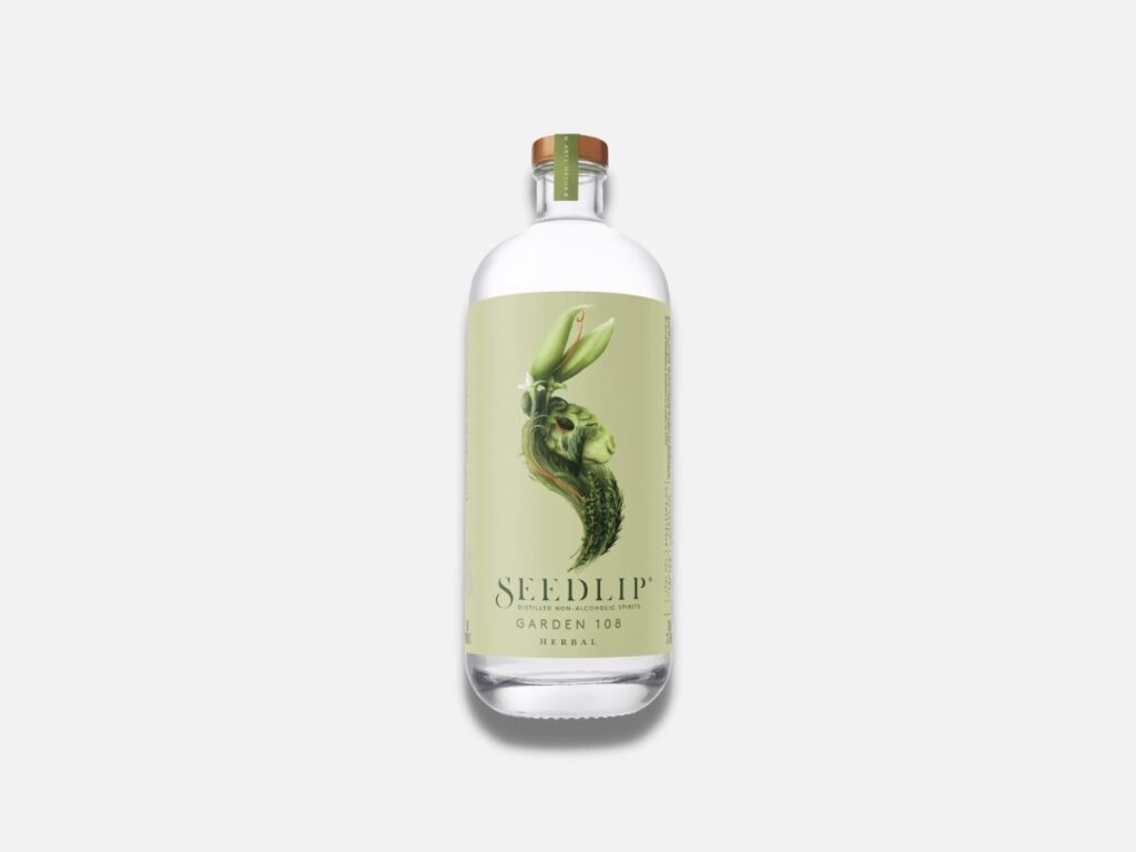
SeedLip Garden 108 captures a summer garden’s crisp, green flavours with a blend of fresh peas, hay, and aromatic herbs such as rosemary and thyme. It is light, clean, and perfect for mixing into spritzers or herbaceous cocktails when you desire something bright and refreshing without the alcohol. Easygoing and full of character, it is made for lazy afternoons and sunny vibes.
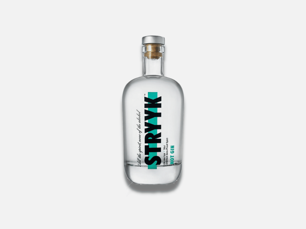
Strykk Not Gin stays true to the classic gin formula with a bold blend of juniper, coriander, sage, and basil, providing a clean herbal kick without the alcohol. It’s sharp, fresh, and designed for mixing zero-proof cocktails that don’t miss a beat. Whether you’re whipping up a G&T or a dry martini, Strykk delivers the bite and backbone you expect need.
Sweet rhubarb, a subtle kick of ginger, and a bright citrus finish blend seamlessly in this bold, playful non-alcoholic gin. Pearsons Rhubarb & Ginger offers a lively, flavorful twist that’s perfect for creating zero-proof cocktails with added character. If you’re looking for a drink that feels fun and a bit different without the alcohol, this one makes a strong case.
CeroCero White Grapefruit & Lemongrass Non-Alcoholic Gin | Image: CeroCero
12. CeroCero White Grapefruit & Lemongrass Non-Alcoholic Gin
Brand: CeroCero
Spirit Type: Non-Alcoholic Flavored Gin
Flavour: White grapefruit, lemongrass, citrus peel
Best For: Bright, refreshing cocktails
Price: Around USD $30
Zesty grapefruit and fresh lemongrass give this non-alcoholic gin a sharp, refreshing edge, perfect for light, citrusy cocktails. CeroCero White Grapefruit & Lemongrass keeps things crisp and clean, offering a bold splash of flavour without the booze. If you’re looking for something bright and uplifting in a glass, this bottle delivers every time.
CleanCo Clean G Non-Alcoholic Gin | Image: Clean Co
13. CleanCo Clean G
Brand: CleanCo
Spirit Type: Non-Alcoholic Gin Alternative
Flavour: Juniper, citrus peel, herbal notes
Best For: Classic non-alcoholic gin and tonics
Price: USD $30
Bright citrus peel, fresh juniper, and gentle herbal notes unite to create a clean, crisp pour that’s perfect for classic zero-proof cocktails. CleanCo Clean G captures the traditional gin experience without the alcohol, providing that sharp, refreshing bite you’d expect from the real thing. It’s ideal for an easy G&T that keeps your glass — and your head — clear.
Best For: Traditionalists who want the real gin taste without the buzz
Price: Around USD $25
Classic juniper, fresh coriander, and a hint of citrus zest make this one of the most recognized non-alcoholic gins available. Gordon’s 0.0% London Dry captures the true essence of the original without the alcohol, providing that sharp, dry finish for which Gordon’s is known. If you’re loyal to the classics but seeking a zero-proof option, this bottle delivers.
Non-alcoholic gin is a spirit crafted to capture traditional gin’s flavours, aromas, and complexity — just without the alcohol. Distilled with classic botanicals like juniper, coriander, and citrus, these zero-proof spirits are designed to provide the same crisp, refreshing bite you’d expect from the real thing. Whether you’re cutting back, taking a break, or looking for a smarter way to sip, non-alcoholic gins allow you to enjoy the ritual of a great cocktail without the buzz.
How Is It Made?
Non-alcoholic gin is crafted using a process similar to traditional gin but with a twist. Distillers begin by blending botanicals such as juniper, citrus, herbs, and spices to develop the flavour profile. Some brands utilize traditional distillation methods and remove the alcohol afterward, while others skip fermentation entirely and create their flavours through cold distillation, steam, or infusion techniques. The goal is to capture the aroma, taste, and complexity of real gin — just without the alcohol content. The result is a spirit that looks, smells, and tastes like the real thing, minus the buzz.
How Does Does It Taste?
A good non-alcoholic gin should taste a lot like the real thing — crisp, botanical, and refreshing. You’ll still experience the familiar bite of juniper, the brightness of citrus, and the layered complexity of herbs and spices. The main difference is the body: without alcohol, some non-alcoholic gins can feel lighter or softer on the palate. The best bottles manage to maintain that classic sharpness and depth, providing a clean, satisfying sip whether you’re mixing a G&T or crafting a full cocktail.
Lyre’s Dry London Spirit | Image: Lyre’s
What to Consider for Non-Alcoholic Gin
Selecting the perfect non-alcoholic gin depends on a few key details. Consider these when choosing your bottle:
Base: A proper non-alcoholic gin requires a robust botanical base, particularly juniper, to achieve that authentic gin character. Without it, the spirit may taste flat or resemble flavoured water rather than a genuine gin alternative.
Flavour: Some non-alcoholic gins are bright and citrusy, while others are herbal, floral, or even spicy. Consider what you enjoy in a traditional gin and pair the flavour profile with the types of cocktails you love to drink.
Price: Quality non-alcoholic gins usually sit between $25 and $50. You don’t have to spend a fortune to get a great bottle, but generally, a higher price means better flavour, better ingredients, and a more satisfying experience.
Choosing the right non-alcoholic gin isn’t complicated — a bit of attention to the base, flavour, and price can help you find a bottle you’ll want to pour repeatedly.
Why Trust Our List?
At Many Men Magazine, we don’t just recommend bottles we’ve read about — we’ve tried them. Our team has tasted, tested, and judged every non-alcoholic gin on this list to ensure it lives up to the real thing. We also relied on genuine customer reviews and feedback to support our experience and provide no great bottle that slipped through the cracks. We believe great taste shouldn’t be limited to drinkers, so we put this list together to ensure everyone — whether you drink or not — can enjoy a proper cocktail without feeling left out. There is no fluff, no paid picks, just honest recommendations based on experience and genuine opinions.
Elias Albay is the Founder and Director of Many Men Magazine, a Toronto-based digital publication dedicated to promoting modern masculinity through style, culture, and self-improvement. What started as a personal turning point became a purposeful platform. — born from Elias’ desire to create something meaningful after completing his studies and finding no career path that truly matched his ambitions. With a background in Civil Engineering from York University and experience in Commercial Flight Operations at CAE, he applied skills, and resilience from both fields to forge a new path.